

ANOTHER unseasonable polar front is due to bring more storms and cold weather to Spain a week after Murcia and Mallorca saw flash floods.
This weather system will sweep in from the north and bring heavy rains, thunderstorms, and a notable drop in temperatures to many parts of the country.
Meteorologists have been warning of this change for several days, and now the first signs are beginning to appear.
Today, a cold front will arrive from the Atlantic, bringing locally heavy and persistent rainfall to Galicia, northwestern Castilla y León, Asturias, and other areas of the Cantabrian coast.
READ MORE: Fresh weather warnings for Spain: Several regions are placed on alert for rain and storms
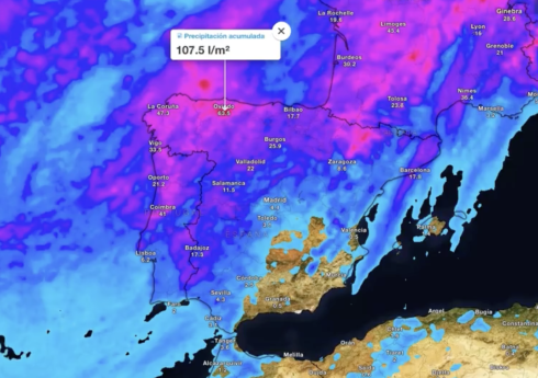
Tomorrow, the cold front will move across the western half of the country, bringing moderate to heavy rains to the Sistema Central, Castilla y León, Extremadura, Alto Ebro, Galicia, and the Cantabrian coast.
This is an unusual situation for mid-June, and it will be accompanied by a noticeable drop in temperatures in the Atlantic regions.
Between tomorrow and Wednesday, the DANA will form and move into the western peninsula.
There is still some uncertainty about its exact trajectory, but the maps show that on Wednesday, heavy rains are expected to fall in much of the western peninsula, the Cantabrian coast, the Pyrenees, Alto Ebro, and Castilla y León.
In the Canary Islands, trade winds will prevail, causing some rainfall in areas most exposed to the northeast.
Meanwhile, the eastern third and Balearic Islands might not be spared again, with a rise in temperatures, dusty skies due to calima, and more potential storms.
Temperatures will fall generally, with abnormally low values for the time of year recorded in much of the peninsula.
But the north and west of the country will suffer the most, with the bad weather lingering over Wednesday and Thursday, with widespread and locally heavy thunderstorms.
The storms will also persist in the northeast, leaving mud, as dust in suspension will continue in the Mediterranean coast and the Balearic Islands.
But the week could end an intense blast of heat.
By Friday, the DANA will have been reabsorbed by the polar jet stream. Heavy rains, locally intense, will be concentrated in the far north, the Pyrenees, and mountainous areas of the northeast.
There may also be some showers in the Balearic Islands, possibly with calima. Between Thursday and Friday, it may even snow above 2,700 metres in the Pyrenees.
Temperatures will rise generally, with the rise being most pronounced in the south.
For next weekend, the outlook is clearer. The most likely scenario at present shows that temperatures of 40°C could return to the Guadalquivir valley and the Guadiana plains, with tropical minimum temperatures on the Mediterranean coast.